Although not part of the Grand Union, the Limehouse Cut connects the Thames with the Lee Navigation. Opened in the autumn of 1770, it's the oldest canal in London. The cut's purpose was to give barge traffic, mainly carrying grain and other agricultural produce from Hertfordshire, a short cut to the Thames, avoiding both the meandering lower reaches of Bow Creek and the River Lea below Bromley-by-Bow and the journey around the Isle of Dogs.
Widened in 1777 and at a later date to allow traffic to flow freely in both directions, other improvements helped stabilize the water level and made the cut easier to negotiate for larger barges. In addition to the Thames, the cut had been connected to the Limehouse Basin's processor for a decade in the mid-19th century and, in 1968, the canal's course was altered when access was restored to the basin and the Thames' entrance abandoned.
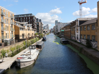
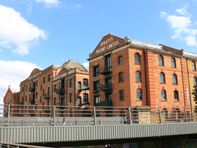
Initially rural in character, the cut benefitted from good transport links and proximity to the docks. Eventually wharfs lined the entire length as the cut's isolated location attracted various enterprises such as chemical and metal refiners, refuse and animal waste recyclers, tar, asphalt and other polluting industries. At just under one and half miles long, the cut packs a fair amount of interest into a small distance. The tow path, although never wide and practically always hemmed in by buildings on both sides, is well made and, on occasions, cobbles provide a reminder of its past.
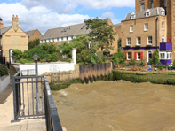
Initially you should visit the former entrance from the Thames which was abandoned in 1968. The adjoining Georgian building at 48 Narrow Street was a public house until 1914. If you cross Narrow Street to Albert Mews, the old line of the cut is still visible where Limehouse Lock was located with accompanying cottages.
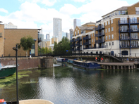
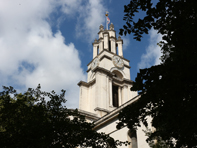
Present day access to the cut is from the south east corner of Limehouse Basin, and the old cut would have joined from the right just before a footbridge at Ropemakers Fields. You'll quickly reach Kings Wharf Park (Tower Hamlets have dispensed with apostrophes), and a detour through this small shaded patch of green will take you to the Grade I St Anne's church designed by Nicholas Hawksmoor. Consecrated in 1730, the church is allowed to fly the White Ensign due to its maritime connections and the flagpole's golden ball appeared on navigation charts as a sea mark.
Next to the church is Limehouse Town Hall and opposite is the old Caird & Rayner works which specialized in marine desalination equipment. Listed due to its architecture and history, the building contains the possibly unique and definitely early example of a complete steel framework structure. Another notable local building is the former Empire Memorial Sailors' Hostel. Dating from 1923 this monolithic structure offered seafarers a bed for the night until the decline of London’s dockyards.
Passing under the railway arches now used by the Docklands Light Railway, you might not realize that this is the world's second oldest urban railway viaduct, built by Robert Stephenson in 1840. Rope was initially used to propel carriages as steam was thought to be too much of a risk considering the proximity of highly inflammable timber yards and rope makers.
You then reach Britannia Bridge. Built between 1851-3, it is the oldest bridge on the cut and carries Commercial Road which connected with the newly constructed West India Docks and had the effect of urbanizing a semi-rural landscape. The nearby 'St Anne's Rookery' was a particularly down at heel area, when Charles Booth visited for his 'poverty map' he found the inhabitants of this 'vile quarter' to be of the 'lowest class, vicious and semi-criminal'.
Boats were once built at Britannia Wharf on the far side of the cut and Copenhagen Wharf was one of the wharfs specializing in recycling anything from rags and bone to coal ash which went to make bricks and oyster shells used by road builders. The cut then straightens towards Bow Locks and is lined with both contemporary residential blocks and less modern industrial buildings. There are moorings at Andersons Wharf before Burdett Road which began life in 1858 as the Victoria Park Approach Road, It was renamed to commemorate Angela Burdett-Coutts, the 'richest heiress in England' who used much of her fortune to finance various philanthropic enterprises in Britain and wider afield. Parliament ensured that the eponymous bridge was 'eight feet above the high water mark' for the benefit of barges.
As the road approaches the canal from the north, its straightness is due to the fact that it was built over the Patent Cable Works which produced 'twice as strong ship's cable'. The Royal Navy demanded rope that was at least 1000 feet in length, hence the need for a long narrow manufacturing location. On the tow path side after the bridge would have been a rope walk where material was laid out before twisting to produce the final product. There are moorings after the bridge and, on the towpath side, was Hermann's furniture factory. The first in England to craft hardwood furniture by machine so that prices could be kept low. Its large stock of timber was manoeuvred by steam crane, an uneasy combination, and the factory was destroyed in a huge fire in 1887. The flames threatened a neighbouring saltpetre works and further catastrophe was avoided by the use of floating fire engines on the cut. There's room for four narrowboats at Abbott's Wharf, they are enveloped by a residential development that boasts 'crisp white render walls' which are 'articulated by an abstract composition of windows', whatever that means.
Just before Bow Common Lane is Bartlett Park that emerged from a bombed out residential area and serves the Lansbury Estate, a housing development named after George Lansbury the Labour leader who was actress Angela Lansbury's grandfather. It's an agreeable location for community events and canoes can be hired if you wish to paddle along the canal. Built in 1929, the Bow Common crossing was originally referred to as Stinkhouse Bridge due to the malodorous local environment created by neighbouring chemical and animal processing factories. Renaming it Lavender Bridge fooled no-one as pollution created from factory waste continued to be dumped into the cut and an ancient sewer called the 'Black Ditch' overflowed regularly into the already filthy water.
Stinkhouse Bridge saw its fair share of suicides which is ironic as the RNLI stored and tested their lifeboats a little further along the cut. The infamous 'Fenian Barracks', another no-go area for law enforcement bordered Furze Street across the canal. A fat refinery attracted hordes of rats and Booth's researchers dubbed it the worst district in London, particularly as the cut acted as an 'open sewer, a sludge filled cesspit brimming with dead animals, human waste and industrial effluent'.
With the East London Waterworks contaminated and some people using the cut for drinking water it was no surprise that a cholera epidemic occurred in 1866. With London benefitting from new sewers and private ones shut down, dredging to remove sediment, and polluters pursued by the council, the canal's water was eventually cleansed. Opposite the tow path immediately before a set of steps leading to the new build houses of Balladier Walk was a 1939 factory building which was built for the Cooperative Wholesale Society as a Joinery Works. The saw tooth roof pattern was the ideal solution to provide workers with sufficient natural light while preventing overheating. Now 'the exchange e3' apartment block mimics this style, and who would know that the site was also once used to produce charcoal from animal bones.
There's a handy mosaic detailing the cut's route on the tow path wall before Violet Road Bridge. Here, dominating the skyline, is the striking redbrick edifice dedicated to the production of pet food that is Spratt's Patent Limited. Once the largest in the world, it closed in 1969 but fish heads by the barge full were once delivered along the cut to be churned into tasty nutritious food for you dog or cat. Biscuits for human consumption were also made here but now, predictably, the former factory is a block of studio flats for East End 'creative types'.
On the other side of the canal is a pleasant area of willow trees included in the Caspian Wharf development. Coal was once loaded onto barges here from the adjacent Devon's Road Goods and Coal Depot to be used in local gasworks and power stations. Go under one of the most nondescript railway bridges you can imagine (formerly the North London Railway, now the DLR), and fields on the far side once yielded clay for the brick industry, these gave way to a tangle of railway sidings with engine sheds adjoining the canal. Now industrial buildings occupy the site. One of them, a furniture manufacturer, largely destroyed by WWII incendiary bombs, utilized travelling cranes in the canal to unload timber from barges.
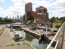
Taking you under the snappily named Blackwall Tunnel Approach Road and dating from 2003, there's an floating tow path. This is on the site of the former Bromley Lock and the remains of one of the gates can still be seen. Towering above you are tower blocks that are perhaps out place with their surroundings and then Bow Locks are reached when you emerge from under the A12. This is a rather desolate, unloved and unkempt location. There are plenty of walkers and cyclists crossing the footbridge over the River Lea but few take any interest in the deserted locks as they make theire way to the historic three mills site and, further on, the Olympic Park.
location information